雷达气象相关词汇(一 扫描模式)

news/2024/11/19 5:29:38/文章来源:https://www.cnblogs.com/jiangleads/p/18348175

参考自https://www.radartutorial.eu/15.weather/wr20.en.html

https://en.wikipedia.org/wiki/Plan_position_indicator

PPI(平面位置显示)
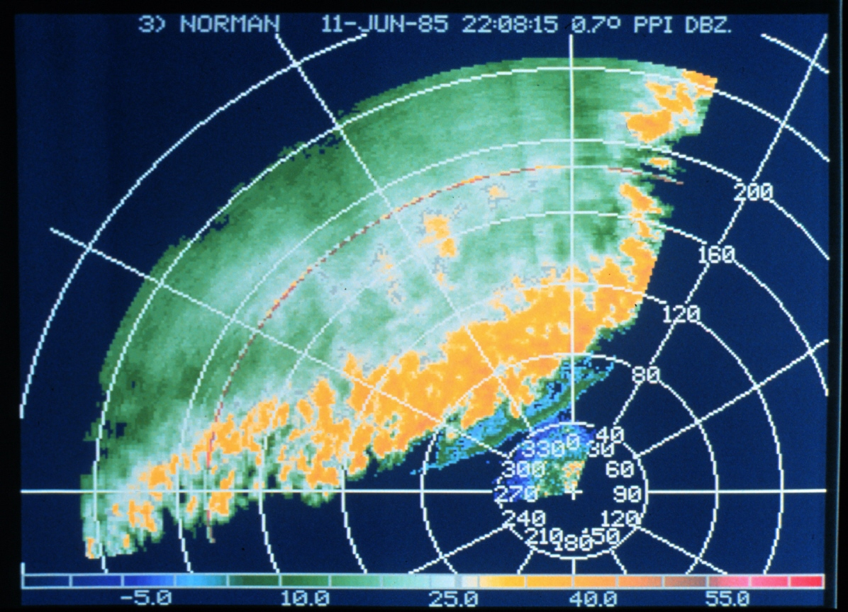
A plan position indicator (PPI) is a type of radar display that represents the radar antenna in the center of the display, with the distance from it and height above ground drawn as concentric circles. As the radar antenna rotates, a radial trace on the PPI sweeps in unison with it about the center point. It is the most common type of radar display.

 PPI图。0.7°仰角。可以看到飑线


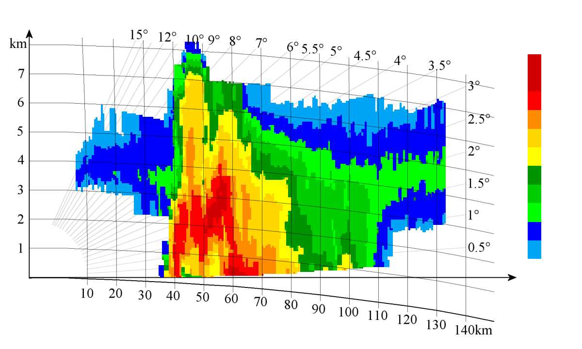
RHI(距离高度显示)

Range Height Indicator (RHI):When scanning in RHI mode, the radar holds its azimuth angle constant but varies its elevation angle. The returns can then be mapped on a vertical plane. The elevation angle normally is rotated from near the horizon to near the zenith (the point in the sky directly overhead).
 

 RHI图


等高面平面位置显示图CAPPI

A CAPPI (Constant Altitude PPI) is a horizontal, two-dimensional representation of radar measurement variables at a certain height. A CAPPI is calculated and interpolated from several PPI measurements at different elevations. On a PPI- Scope, the different heights will be mostly represented by color variations. A so-called pseudo-CAPPI (pCAPPI) differs from a CAPPI in that additional values in the far zone are extrapolated.


体积恒定-等高面平面位置显示图Vol-CAPPI (“三视图”)

另一个显示选项称为体积恒定-等高面显示图 (Volume-CAPPI),允许在所有三个横截面中进行清晰的回波分配。除了底层平面图之外,还显示立面图(对应于从东到西的侧立面图)和单个横向立面图(对应于从北到南的侧立面图)。借助十字光标,可以选择这些横截面的位置。Another display option is called Volume Constant Altitude Plan Position Indicator (Volume-CAPPI) and allows a clear echo assignment in all three cross-sections. In addition to a floor plan, an elevation (corresponds to a side elevation from east to west) and a single cross elevation (corresponds to a side elevation from north to south) are shown. With the help of a crosshair-cursor, the positions of these cross-sections can be selected.
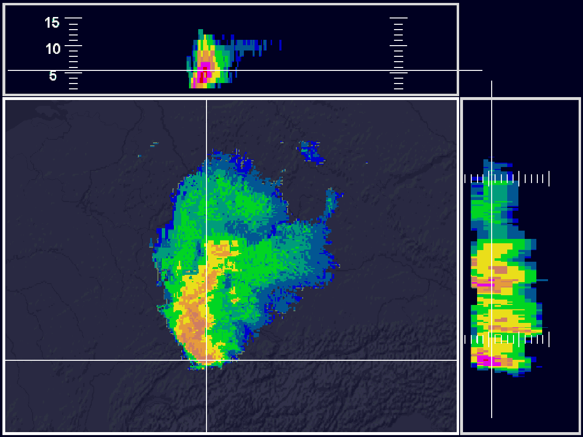
 

 Vol-CAPPI-显示


最大等高面平面位置显示图MAX-CAPPI

In a MAX-CAPPI (Maximum Constant Altitude Plan Position Indicator) maxima of CAPPI data from different heights are displayed. This is done on the one hand by a vertical maximum projection in an (image) elevation, on the other hand by horizontal maximum projections from south to north or from west to east in side elevations. In the side elevations, the lateral scale indicates the height in km. In a MAX-CAPPI mostly reflectivities are shown.


多站点雷达拼图Composites across multiple sites

Combining the radar images of different locations into a composite image opens up further possibilities for weather analysis and forecasting. In most cases, only local reflectivity composites are further processed across locations. The advantage is a large-scale overview. The disadvantage is the poorer accuracy compared to local products.


垂直液态水积分Vertically Integrated Liquid (VIL)

Vertically Integrated Liquid (VIL) is the total amount of rain that would fall if all the liquid water in a column within a rain cloud (usually a thunderstorm) reached the surface of the earth. Basically, all water quantities estimated on the basis of reflectivity are added over a grid-like distributed unit of area.

VIL is not observed or measured, but calculated based on the reflectivity measured by the radar. Thus, everything that influences the reflectivity has an effect on the VIL.

 

本文来自互联网用户投稿,该文观点仅代表作者本人,不代表本站立场。本站仅提供信息存储空间服务,不拥有所有权,不承担相关法律责任。如若转载,请注明出处:http://www.hqwc.cn/news/779546.html

如若内容造成侵权/违法违规/事实不符,请联系编程知识网进行投诉反馈email:809451989@qq.com,一经查实,立即删除!

相关文章

searchLights 动画

LOGO扫光效果.logo { width: 200px; height: 70px; display: flex; line-height: 70px; position: relative; overflow: hidden } .logo img { width: 100%; height: 70px } \3c p>.logo:before { } \3c br> @-webkit-keyframes searchLights { } \3c br> @-o-keyfram…

JavaWeb后端开发2024-08-08

Maven Apache Maven 是一个项目管理和构建工具,它基于项目对象模型(POM)的概念,通过一小段描述信息来管理项目的构建。Maven作用 依赖管理统一的项目结构项目构建仓库安装Maven<mirror> <id>alimaven</id> <name>aliyun maven</name> <u…

Golang语言之gRPC程序设计示例

作者:尹正杰 版权声明:原创作品,谢绝转载!否则将追究法律责任。 目录一.RPC协议介绍1.什么是RPC2.什么是GRPC3.安装gRPC环境3.1 使用gRPC的前提3.2 安装protoc3.3 安装go plugin二.Protocol Buffer的使用指南1.使用Protocol Buffer的基本流程概述2.编写产品服务等proto文件…

迅雷赚钱宝1代刷OpenWRT单网口接在主路由下,内网访问正常,外网无法访问的解决办法。

1. 问题缘由OpenWRT单网口NAS(迅雷赚钱宝1代),接在主路由下面提供NAS服务,配置有基于eth0的DHCPv6Client来获取IPv6公网IP,以实现通过IPv6公网,提供对外的NAS服务。发现在局域网访问DDNS-go的管理界面9876端口正常访问,DDNS-go已允许外网访问,但通过手机数据流量模拟外…

c#农历开源库

https://6tail.cn/calendar/api.html非常牛逼 Unity将当前时间转为天干地支using System; using Lunar; using UnityEngine;public class GanZhiTimeConverter : MonoBehaviour {private void Start(){var solar = Solar.FromDate(DateTime.Now);Debug.Log(solar.Lunar.YearInG…

关于算法竞赛,青岛农业大学ACM实验室简介

大家好,我是青岛农业大学ACM实验室的杨兴睿,一名帅气的acmer~( ̄▽ ̄~)(~ ̄▽ ̄)~,尽管你在官网或者其他地方看过各种各样天花乱坠的宣传,我可以很明确的告诉你那是不真实的,今天用这篇博客给大家介绍一下最真实的ACM实验室。 我们先从算法竞赛开始讲起吧,算法竞赛也是…

18. 内置函数

1. 概念 内置函数是python解释器自带的函数,不需要导入模块就能使用,69个官网介绍https://docs.python.org/3/library/functions.html#staticmethod 2. 数据类型转换  8个(1)整数类型转换 int# 将内容为整数的字符串转换为整型 a = 666 print(int(a)) # 666(2)浮点数…

全网最适合入门的面向对象编程教程:33 Python 的内置数据类型-对象 Object 和类型 Type 的关系

对象是某个类型的实例,是内存中的实体,有类型和属性;在Python中,类型本身也是对象,所有的类型(类)都是type类型的实例。全网最适合入门的面向对象编程教程:33 Python 的内置数据类型-对象 Object 和类型 Type 的关系摘要: 对象是某个类型的实例,是内存中的实体,有类…

画廊 (2023 年 2 月至 2023 年 10 月)

Gallery (I)上图于 2023 年 4 月 5 日摄于保定。上图于 2023 年 4 月 22 日摄于北京平谷。上图于 2023 年 5 月 1 日摄于贵阳。上图于 2023 年 5 月 3 日摄于石家庄正定。上图于 2023 年 5 月 3 日摄于石家庄正定。上图于 2023 年 9 月 16 日摄于张家口下花园。上图于 2023 年 …

benchmarkaql测试MariaDB

下载benchmarksql (1)首先从github 直接下载源码 (2)修改src/client/jTPCC.java文件 vi src/client/jTPCC.java在123和124行增加如下内容:else if (iDB.equals("mariadb")) dbType = DB_UNKNOWN;(3)修改src/client/jTPCCConnection.java文件 vi src/c…

FreeRTOS挂起和恢复任务相关函数解析

目录函数 vTaskSuspend()函数 vTaskSwitchContext()函数 vTaskResume()函数 xTaskResumeFromISR() 以下FreeRTOS源码函数使用的版本是9.0.0,不同版本的源码会有部分不同如10.4.6,注意甑别。 挂起和恢复任务相关 API 函数有以下几个:函数 vTaskSuspend() 此函数用于挂起任务,…