首先得去高德控制台申请两个 key,一个天气key和一个定位key

获取天气信息的函数:
const getWeather = function (city) {// 使用 fetch 发送请求获取天气信息fetch(`https://restapi.amap.com/v3/weather/weatherInfo?city=${city}&key=eefd36557b0250d19d243aea0f62d499`).then((response) => response.json()).then((data) => {const { lives } = data;// 更新响应式数据weather.city = lives[0].city;weather.weather = lives[0].weather;weather.temperature = lives[0].temperature;weather.winddirection = lives[0].winddirection;weather.windpower = lives[0].windpower;weather.reporttime = lives[0].reporttime;});
};
使用Geolocation API获取当前位置:
onMounted(() => {let latitude = 0;let longitude = 0;if ("geolocation" in navigator) {navigator.geolocation.getCurrentPosition(function (position) {latitude = position.coords.latitude;longitude = position.coords.longitude;},function (error) {console.error("获取位置失败:", error.message);});} else {console.error("浏览器不支持Geolocation");}
});
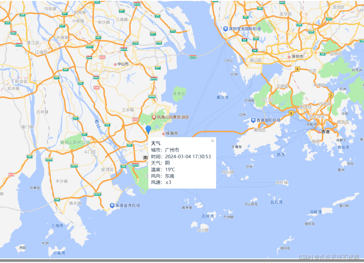
加载高德地图API并在地图上显示标记和天气信息:
AMapLoader.load({// 加载高德地图API
}).then((AMap) => {// 在地图上显示当前位置的标记const marker = new AMap.Marker({position: new AMap.LngLat(longitude, latitude),title: "当前位置",});// 其他地图初始化和相关操作// 在地图上显示信息窗体watch(weather, (newVal, oldVal) => {// 创建信息窗体var content = ["<div><b>天气</b>",`城市:${weather.city}`,// 其他天气信息..."</div>",];var infoWindow = new AMap.InfoWindow({content: content.join("<br>"),anchor: "top-left",});infoWindow.open(map, [longitude, latitude]);});// 添加标记到地图map.add(marker);// 标记点击事件marker.on('click', function (e) {// 打开信息窗体infoWindow.open(map, [longitude, latitude]);});
}).catch(e => {console.error(e);
});
全部代码
<template><div id="container"></div><!--  -->
</template>
<script setup lang="ts">
import {onMounted, reactive, ref, watch} from 'vue';
import AMapLoader from '@amap/amap-jsapi-loader';
import {computed} from "vue-demi";// 如果是在 ts 的项目中,这一步会有类型错误,解决方案请移步 2.1.1
window._AMapSecurityConfig = {securityJsCode: 'd6a5157a0b06c55bcee22c7b69a42c5a'// 你的安全密钥
};
// 定义当前经纬度
/** 初始化地图函数 */
// IP定位获取当前城市信息
const weather = reactive({city: '',weather: '',temperature: '',winddirection: '',windpower: '',reporttime: ''
})
const weatheritem = computed(() => {// 回调函数必须return,结果就是计算的结果// 如果计算属性依赖的数据发生变化,那么会重新计算return weather
})const getWeather = function (city) {fetch(`https://restapi.amap.com/v3/weather/weatherInfo?city=${city}&key=eefd36557b0250d19d243aea0f62d499` //天气key).then((response) => {return response.json();}).then((data) => {const {lives} = dataconsole.log(lives[0])weather.city = lives[0].cityweather.weather = lives[0].weatherweather.temperature = lives[0].temperatureweather.winddirection = lives[0].winddirectionweather.windpower = lives[0].windpowerweather.reporttime = lives[0].reporttime});
}
onMounted(() => {let latitude = 0;let longitude = 0;// 获取当前位置的经纬度
// 检查浏览器是否支持Geolocationif ("geolocation" in navigator) {// 获取当前位置navigator.geolocation.getCurrentPosition(function (position) {// 获取经纬度latitude = position.coords.latitude;longitude = position.coords.longitude;// 在这里使用经纬度数据进行其他操作console.log("纬度:" + latitude + ", 经度:" + longitude);},function (error) {// 处理获取位置失败的情况console.error("获取位置失败:", error.message);});} else {// 浏览器不支持Geolocationconsole.error("浏览器不支持Geolocation");}// AMapLoader => 加载器// 资源加载完成后就会触发 thenAMapLoader.load({"key": "34b7b1e632fcf24d30be5c5825f8043d", // 申请好的Web端开发者定位Key,首次调用 load 时必填"version": "2.0",   // 指定要加载的 JS API 的版本,缺省时默认为 1.4.15"plugins": [],           // 需要使用的的插件列表,如比例尺'AMap.Scale'等}).then((AMap) => {AMap.plugin('AMap.CitySearch', function () {var citySearch = new AMap.CitySearch()citySearch.getLocalCity(function (status, result) {if (status === 'complete' && result.info === 'OK') {// 查询成功,result即为当前所在城市信息console.log(result.city)getWeather(result.city)}})})const marker = new AMap.Marker({position: new AMap.LngLat(longitude, latitude), //经纬度对象,也可以是经纬度构成的一维数组[116.39, 39.9]title: "当前位置",});//打开信息窗体// 初始化地图const map = new AMap.Map('container', {center: [longitude, latitude], //地图中心点zoom: 10// 配置对象 - 配置地图的风格和缩放比例,请移步 2.2});//获取当前城市信息//信息窗体的内容watch(weather, (newVal, oldVal) => {console.log(newVal, oldVal)var content = ["<div><b>天气</b>",`城市:${weather.city}`,`时间:${weather.reporttime}`,`天气:${weather.weather}`,`温度:${weather.temperature}℃`,`风向:${weather.winddirection}`,`风速:${weather.windpower}`,"</div>",];
//创建 infoWindow 实例var infoWindow = new AMap.InfoWindow({content: content.join("<br>"), //传入字符串拼接的 DOM 元素anchor: "top-left",});infoWindow.open(map, [longitude, latitude]); //map 为当前地图的实例,map.getCenter() 用于获取地图中心点坐标。})map.add(marker)marker.on('click', function (e) {// 打开信息窗体,显示信息console.log(e)infoWindow.open(map, [longitude, latitude]);});}).catch(e => {console.log(e);});
});</script><style scoped>
#container {width: 100vw;height: 100vh;
}
</style>


